

The Cape Otway Lightstation
21 March 2016
We were up bright and early as it will be a long day today – breakfast will wait until we have covered some kilometres! Before we left Apollo Bay we wanted to spend a while looking around the town, it has a picturesque beach, and we also visited the fishing harbour (all coastal towns have a fishing harbour and it is interesting to see the boats and the activity).
 Then it was only a short drive to Cape Otway and we were soon at the turn off. The scenery was beautiful, thick forestation and rainforest, the road is quite winding but interesting. At the entry we paid our fee (seniors’ concession!) and set off for a walk around the Cape area. Most of the original buildings are still in existence, and the telegraph station was especially interesting. The morse code machine was working, and it was interesting to learn how the telegraph first started and eventually linked up communities from Tasmania to Northern Australia.

Cape Otway Lightstation is the oldest surviving and most important lighthouse in mainland Australia. Built in 1848, the lighthouse perches on towering sea cliffs where Bass Strait and the Southern Ocean collide (left). Hundreds of lives were lost in shipwrecks off Cape Otway – a sad but fascinating history which led to the building of the Lightstation on the coast at the foot of the impenetrable forests of the Otways.
For many thousands of 19th century migrants, who spent months travelling to Australia by ship, Cape Otway was their first sight of land after leaving Europe. We declined the climb to the top of the light station but the views from ground level up and down the coast are stunning.

A cafe is now housed in what was the home of the Assistant Light House Keeper, and we had a nice breakfast overlooking the light station (above). This was to be a day of turning off the main road to numerous lookouts along the coast, the first one after Cape Otway was Castle Cove Lookout over Johanna Beach.
To arrive there we travelled from Cape Otway and along the Aire Valley – a beautiful area surrounded by hills, the valley itself is very flat so one can see the whole valley. At the Castle Cove Lookout we were not only able to see fabulous views down the coast, but the whole Aire Valley was spread out in front of us (below).

Our journey was then directed into the hinterland, the highest point was Lavers Hill – “where the forest meets the sea”. Although we caught a glimpse of the ocean from time to time on the descent to the coast, the forests were green and serene to drive through.

Princetown was our next stop, a tiny town with fabulous views over the Gellibrand River and valley (above). Shortly after Princetown we took another turn off the main road, to visit two farms along the Otway Gourmet Food Trail – first stop was the Gorge Chocolate Factory for a taste of their wares (below). The chocolate coated licorice was interesting, one Raspberry flavoured, and the other Lochard Licorice – we also purchased a block of mint chocolate and some Buderim ginger. I am eating a Lochard Licorice now and it is yummy!


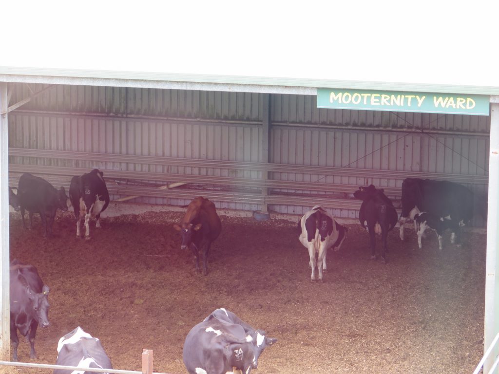 Second stop was at the Apostle Whey Cheese Factory (above left) where we had a tasting of their various cheeses, and were able to watch the cheese being made (above right). There was a very cute old Cocker Spaniel dog who was asleep when we arrived and opened one eye to watch us, and he was still there when we left. From the factory we were able to see the Mooternity Ward (left) – where expectant cows are cared for! There was one young calf that had been born that morning, (back right of the ward) very cute! We bought three different cheeses and some sour dough bread – so dinner tonight will be cheese, biscuits, sour dough bread, grapes and apple – and some red wine!
Then it was time to return to the main road and continue along the Great Ocean Road, first of all to see the Twelve Apostles (only 8 left). Although I had visited this area before, about 10 years ago, it is a fabulous sight.
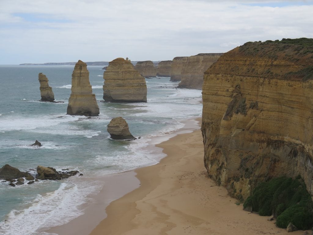
The iconic golden cliffs and crumbling pillars of the Twelve Apostles are protected by the Twelve Apostles Marine National Park which covers 7500ha and runs along 17km of stunning coastline. As well as the water beauty the park protects some of Victoria’s most dramatic underwater scenery. Spectacular arches, canyons, fissures, gutters and deep sloping reefs make up the environment below the waves. Wild and powerful waves of the Southern Ocean constantly pound the coastline which has shaped the area into what you see today.
The remarkable underwater structures provide a complex foundation for magnificent habitats including kelp forests and colourful sponge gardens. Many animals prosper both above and below the water including seabirds, seals, lobsters, reef fish and sea spiders. The intertidal and shallow subtidal reefs are known to have the greatest diversity of invertebrates on limestone reef in Victoria. Marine mammals, such as whales, are also known to visit the area. Patient visitors after dark or in the early morning may see Little Penguins which nest in caves below the Twelve Apostles.

There were hundreds of tourists visiting the Twelve Apostles, tourist buses everywhere, mainly overseas visitors all clicking cameras and taking selfies! We found a fabulous motor cycle that would be great to drive along the Great Ocean Road, except maybe in wet weather! (right)
Next feature is the spectacular Loch Ard Gorge. The sheer size of the cliffs and the narrow opening out to sea at the Loch Ard Gorge is amazing. In rough weather the crashing waves put on quite a show , and the surf was crashing today .

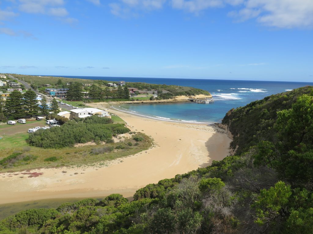
Port Campbell is the town in the centre of the Great Ocean Road, a lovely small beach with a cliff similar to that of the coast (below left). We had not eaten since breakfast so we had a mid-afternoon snack of a meat pie and a latte before we drove further along the Great Ocean Road, taking another photograph of Port Campbell from the lookout above the town (below right).

The Arch was our next stop. We saw the natural rock formation formed through erosion, at its best during rough seas when the waves crash in and around the arch. There is also an excellent view back towards the Twelve Apostles.

Our last glimpse of the rock formations was The London Bridge, originally a natural archway and tunnel in an offshore rock formation, however, the arch collapsed in 1990 and became a bridge without a middle (below).

The time was passing quickly, and I had lost count of the number of times we had left the car, walked to a viewing site, then back to the car again – we certainly did a lot of walking and sightseeing today! Our final destination was Port Fairy, so we did not stop again as we passed through the city of Warrnambool, and finally to our destination by 6pm. We are staying at Seacombe House which has quite a history.
Port Fairy is a historic fishing town located on Victoria’s far south-west coast on the Moyne river. The main focal point of Port Fairy is the Moyne River as it approaches the coast. The Fishermans Wharf area along the river is lined with boats and fishing craft, and good views of river activity can be enjoyed from the footbridge over the Moyne. Another good viewing spot is from the historic fortifications at Battery Hill which is located at the southern end of Griffiths Street. Views can be enjoyed over the Moyne River and to the ocean.
Griffiths Island is situated at the mouth of the Moyne River and is linked to the coast via a pedestrian causeway. The island is home to a large colony of mutton birds, while at the eastern end of the island is the Port Fairy Lighthouse. A walking track circumnavigates the island.
Tomorrow morning we will explore this delightful town, before we leave for our next destination Mount Gambier in the lovely state of South Australia.
